Background Information
On March 26, 2012, the U.S. Census Bureau released the 2010 Urban-Rural classifications. The Census Bureau’s urban areas represent densely developed territory and encompass residential, commercial, and other nonresidential urban land uses. The Census Bureau identifies two types of urban areas: “urbanized areas” of 50,000 or more people and “urban clusters” of at least 2,500 and less than 50,000 people. “Rural” encompasses all population, housing and territory not included within an urban area. There are 486 urbanized areas and 3,087 urban clusters nationwide.
The Census Bureau’s urban and rural classification provides an important baseline for analyzing changes in the distribution and characteristics of urban and rural populations. The Census Bureau’s urban areas also form the cores of metropolitan and micropolitan statistical areas, as defined by the Office of Management and Budget, and are used in other agencies’ and organization’s urban and rural classifications.
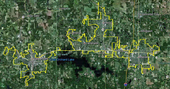
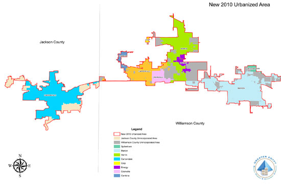
For 2010, the U.S. Census designated 36 new Urbanized Areas in the United States including two affecting southern Illinois communities, one is located along the Route 13 Corridor which has a population of 67,821, and a second which is centered in Cape Girardeau, Missouri that includes parts of East Cape Girardeau in Illinois and has a total population of 52,900. Along the Route 13 Corridor there are nine Illinois municipalities spanning two counties in the Urbanized Area’s boundary. The communities included are: Cambria, Carbondale, Carterville, Colp, Crainville, Energy, Herrin, Marion, Spillertown, Jackson County, and Williamson County.
2010 Census – Urbanized Area Reference Map: Carbondale, IL
>> SIMPO 2010 Census Urbanized Area Map
 >> Download a PDF file (3.9 MB) to view a larger version of this map. |
 >> Download a PDF file (844 KB) to view a larger version of this map. |
- Data users and researchers interested in analyzing data for urban and rural population and housing use the Census Bureau urban and rural areas, and data tabulated for those areas.
- Analysts use urban area data to study patterns of urbanization, suburban growth and development, and urban/rural land area change.
- Various federal and state agencies use the Census Bureau’s urban and rural definitions as the basis for their own urban and rural definitions and settlement classifications for use in tabulating and presenting statistical data. The National Center for Education Statistics uses the Census Bureau’s urban and rural definitions in its locale codes classification. The US Department of Agriculture uses the Census Bureau’s urban-rural classification as the basis for various urban and rural classifications used to analyze and report on demographic and economic patterns in rural areas.
Other government agencies use the Census Bureau’s urban and rural definitions to determine program eligibility and funding formulas. For example, the Federal Highway Administration uses Census Bureau urbanized areas to qualify Metropolitan Planning Organizations.
Additional information regarding Census Urbanized Areas may be found at the Federal Highway Administration’s Census Issues webpage.